


Digital elevation model (DEM) is one of the most important components of GIS technologies. It does not require field research throughout the study area and thus gives the fused dataset elevation. DEM especially important for three-dimensional geoinformation modeling of mineral deposits, because it is the most effective means of spatial organization without vertical positioning
Initiative scientific work often not involves the allocation of special funds for land activities, procurement of accurate satellite data, and another ways, which would allow you to create accurate DEM. Is of interest the methods of constructing the most accurate terrain models based on aggregation of open, publicly available sources of geo-information [1], and the development of methods of creating such models for typical landforms or certain areas of the earth’s surface. This data includes satellite - AsterGDEM (Global Digital Elevation Model) and SRTM (Shuttle radar topographic mission), and topographic maps of scale 1: 200,000, 1:100,000.
Most often, researchers at DEM studied objects used a relatively simple method of constructing a triangulated irregular network (TIN-model), which is a layer representing a continuous field of height values to give an image bulk form [2]. However, in the case of mountainous areas and maps scales under consideration, the obtained models are characterized by the presence of the linear approximation and smoothing are contour landforms that are often unacceptable. To eliminate the effect of approximation is necessary to fill the space between the contours additional geodata. Nevertheless, this «topo»contours are necessary for inclusion in the final model, and in addition are the standard, allowing to draw conclusions about the accuracy of generated DEM [3].
The problem was solved by the example of the Eastern Sayan mountain. Complex studies have shown that to fill the space between the contours on a topographical map of the territory to altitudes below 2160m should use data AsterGDEM, the height of 2160 or higher - SRTM 4.2. Be aware that the remote sensing data are smoothed higher forms of relief: for correct modeling of mountain peaks (from 2720m) in both cases it is necessary to use the data points heights with topographic maps , otherwise there will be their smoothing [3]. After finding the spatial limits of applicability of certain types of geo-information may start finding methods of interconnecting remote sensing and topographical map.
Must take into account the formats in which the source data are presented: Earth remote sensing data are regular DEM-raster (the ERS-DEM), while the topographical map shows irregular vector lines and points.
The most obvious way to clarify relief - reformatting ERS -DEM heights in an array of points XYZ (latitude, longitude and elevation of the point ) and its subsequent addition to topographical contours relief, broken by periods. This method does not give the expected result acceptable in the real world: linear interpolation algorithms form a “step” in the area contour model. Trying to eliminate this effect by buffering the contour using a topographical map of zones of varying size and subsequent clipped from ERS -DEM falling within this zone points for alpine areas also does not give positive results.
The most applicable method for interconnecting selected the following method. The first step is re- TIN- model (data formed from topographic map) in GRID- point array of XYZ regular grid 5x5 m, then made export data and SRTM DEM and AsterGDEM to GRID XYZ in the network of the same dimension , and made a simple addition of these two arrays.
It should be noted that the dimension of 5x5 m not random and obtained empirically: a series of models with different constructions of cell size , the same as for maps and remote sensing (20x20, 15x15, 10x10, 7x7, 5x5, 3x3), and different (5x10, 10x5) shows that a reduction cells does not lead to improved results, but requires significantly more computing resources.
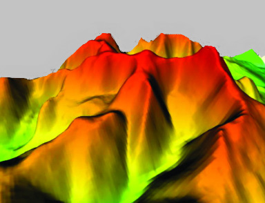
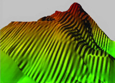
Fig. 1. a) DEM topo 7 x 7SRTM, b) 5 x 10 topo SRTM, c) 5 x 5 topo SRTM ( model and contour)
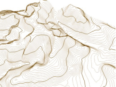
By the above procedure was carried out to build a model of the terrain located thereon trigonometrical point that allowed us to estimate the accuracy of the model. It was found that the developed DEM differs from real relief to 3m, while GPS- navigator gives an average error of up to 15-17 m vertically [4]. Also proved that the procedure established by DEM precisely here any single open source data at all altitudes (Fig .2).
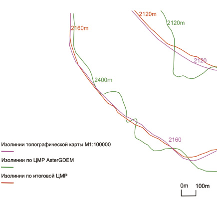
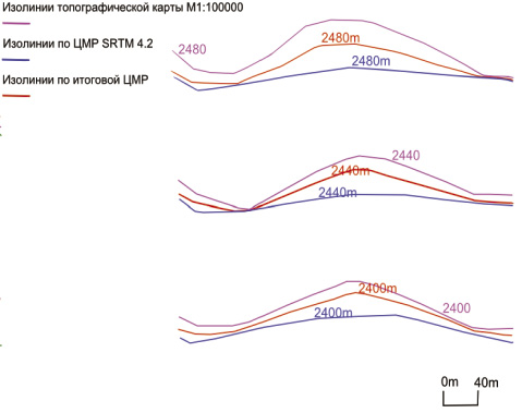
Fig.2. Green – AsterGDEM isolines, Cyan – topo isolines, Blue – SRTM isolines, Red – isolines from final complex DEM.
The proposed method can produce a DEM for various types of geological problems.
Библиографическая ссылка
Demina O.I., Parshin A.V., Shestakov S.A. COMPARISON OF DIFFERENT METHODS OF AGGREGATION OPEN GEODATA TO CONSTRUCT A MAXIMALLY ACCURATE DIGITAL ELEVATION MODEL // Современные наукоемкие технологии. 2014. № 7-2. С. 35-36;URL: https://top-technologies.ru/ru/article/view?id=34289 (дата обращения: 15.07.2026).